Mawlersĺ Big Adventure ĺ04:
On the Road - Eagle Plains to Inuvik
Sunday, 1 August 2004
|
||||
|
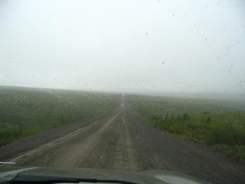
We went to bed last night at 3 am and it sure looked like the sun was still up. We wake up at 9 am and the sun is no longer up. At least, it sure looks that way. There is nothing but fog and we cannot see more than 20 yards or so; this could be a rough trip. We go and have breakfast / lunch and sometime during all that, the sky clears up. The day is bright and sunny from just north of Eagle Plains to just beyond the border with the Northwest Territories.
Pulling over to take pictures of the mountains in the fog, we meet a local. This fellow informs us that we just missed a Grizzly Bear walking through the meadow. Did we forget to mention that a bear walked by the Liard Hot Springs when we were sitting in them? We missed that one, too. Today, trucks and campers abound on the road. What is this, arctic rush hour? I think it has something to do with the Midway Music Festival at the Midway Campgrounds up ahead. Shortly, we pass the campgrounds, which are indeed full of people and tents. They are all very wet. We do not stop. Shortly after the music festival, we do manage to see a fox. This critter is as big as a sizable dog! I am not talking about a Jack Russell Terrier or anything. This thing appears to be closer in size to a Retriever. Of course, he might be mostly tail. Eventually, we make it to the first of two river crossings. The first is here at the Peel River. Both are maintained by the territorial government and are free. In the winter, they beach the ferry and traffic drives right across the frozen river. The problem comes in the spring and fall. In the fall, the ice is not thick enough, but too thick for a ferry. The same is true in the spring, but there is the added problem of giant ice cubes and trees washing down the river, so no ferry then either. I guess you fly. In Fort McPherson, just beyond the Peel River, The Tent & Canvas Shop is fascinating. They make teepees, huge festival tents, tents for safaris, bags, tarps, you name it. They let us wander around on the shop floor and look at the operation. The embroidery machines are huge; they have instructions printed in English and Japanese. We end up buying two parkas and a fleece pullover for just CDN$137. Not a bad deal and, who knows, the parkas might come in handy.
The Shop manager is an interesting fellow who apparently travels to odd places to manage struggling businesses. The Tent & Canvas Shop was losing money every year, so they called him in to make it profitable. By his report, he is making it work. Still somewhat the outsider, the manager relates amusing stories about the locals. In particular, he likes the way they use the local radio stations. He says that, when listening, it is a regular thing to hear an announcement of this sort: "Pete, turn on your bush radio!" It is not known whether Pete ever gets the message. Just under 60 more km up the road, we come to the MacKenzie River crossing at Tsiigetchic, formerly known as "Arctic Red River". A lot of places have been changing names up here since the late 1980s when most of the First Nations Land Claims settlements were reached with the Canadian Federal Government. Over in Nunavut Territory, they have a Bureau of Place Name Changes to handle the rush. The ferry crossing at Tsiigetchic is peculiar. This ferry makes a triangle pattern because there is a large tributary to the MacKenzie right here. As a result, the ferry cannot use the normal safety line to help drag itself across the river and keep square with each bank. Driving up the Dempster, we get on at the MacKenzieĺs west bank and the ferry pulls away, making a sharp right, chugging upstream to the Tsiigetchic landing, where we get off to see what the town is like and get our Dempster Highway Passport stamped. The ferryman gives us a very strange look. I have a feeling that this is the land of the VFW ľ Very Few Whites. Later we come back to the landing and catch the ferry again. This is the longest leg of the triangle, where it travels roughly downstream from Tsiigetchic landing to the east side of the MacKenzie.
As most of you know, a ferry has two ends. In normal operation, people enter one way and just pull straight off the other end when they get to the next landing. However, things get tricky when a two-ended ferry makes three stops. When we get on the ferry at Tsiigetchic landing, there are four vehicles pointing nose-out toward us, but they are not getting off here; they are going to Inuvik and need to cross the MacKenzie. We get on the ferry pointing the opposite direction, but intending to go to Inuvik as well. With us, gets on one other truck going to the southbound Dempster. The solution is quite simple really. After the ferryman and the captain negotiate about directions, the boat gets turned so that the majority of the passengers are facing nose-out on the northbound Dempster landing. That would be everyone but us. When it comes to our turn, we back off the ferry. Yes, this is a new one for me. We back off the ferry in reverse. From here it is an uneventful trip to Inuvik, where we take a spin through town. This is actually a sizable community. The town sign says the population is around 4,000, though it seems like everyone we meet here is from somewhere else. We easily find our accommodations at the Arctic Chalet. Well, we find the Arctic Chalet, but the room is somewhat more difficult. At remote locations, people often abandon the "front desk" and leave instructions on how to find someone. These instructions tell us to go knock on the staff trailer. And it is a trailer. The young university student looks bewildered and says he will be right there to help us. While all a bit uncertain and somewhat off-putting, we have a nice room with a kitchenette right down by the dog kennels. Surprisingly, the dogs are quiet at night. Considering that it never really gets dark, this is quite a feat. Or is it a paw? |
||||
|
|
||||
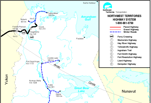 see it on a map |
||||
|
|
||||
|
The previous installment: |
The next installment: |
|||
Back to Great White North Trip main page
Back to Mawler Home
All materials © 2004 Lea Ann Mawler & Stuart Mawler