Mawlers’ Big Adventure ’04:
On the Road - Dawson Creek to Fort Nelson
Tuesday, 27 July 2004
|
|||
|
After all our careful packing and planning, we are finally to the core of the trip. Wait, what did I say? Nevermind. Even yesterday (Monday) was merely preparation for today. In point of fact, yesterday was 622.7 kilometers of preparation, driving from our hotel near the airport to Dawson Creek. You see, Dawson Creek is the current official beginning of the Alaska Highway (“Mile 0”). People from Fort Nelson are quick to point out that they were “Mile 0” for a couple of years before Dawson Creek. So there. It is an auspicious beginning to our trip. We manage to go off-road in our 4x4 (on purpose, mind you), taking a side-trip down to the river’s edge right outside of Fort Nelson to spend time reading and watching the locals drive their ATVs across the river. The water level seems low…
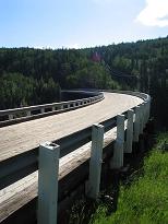
On the way to the river, we happen to drive a short way behind a truck, which kicks up one small stone. This tiny rock (about the size of a regular number two pencil eraser) hits the base of the windshield below the wiper and creates an instant crack about two inches long. Also on this portion of the road, we decide to take a side trip on an old part of the Alaska Highway, taking us over an original wooden bridge. Very cool. The first time we notice that we lack cell service is in the mountains between Dawson Creek and Fort Nelson, BC. Interesting Cultural Tid-Bit:
We stop at "Mile 36 Café" in Taylor, BC. As we get up to leave, I visit the washroom and Lea Ann walks to the cash register to pay. Apparently, women’s liberation has not quite percolated to this region because the waitress is incensed by my presumption to have a woman pay for lunch! I am surprised that she does not follow me into the washroom to demand redress. |
|||
|
|
|||
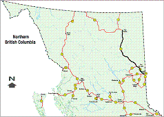
 see it on a map |
|||
|
|
|||
|
The previous installment: |
The next installment: |
||
Back to Great White North Trip main page
Back to Mawler Home
All materials © 2004 Lea Ann Mawler & Stuart Mawler
